A tool for creating SVG timelines from simple JSON input.

Overview

Timeline

A tool for creating SVG timelines from JSON.

Example

You will be able to create timelines that look like this:

simple timeline example

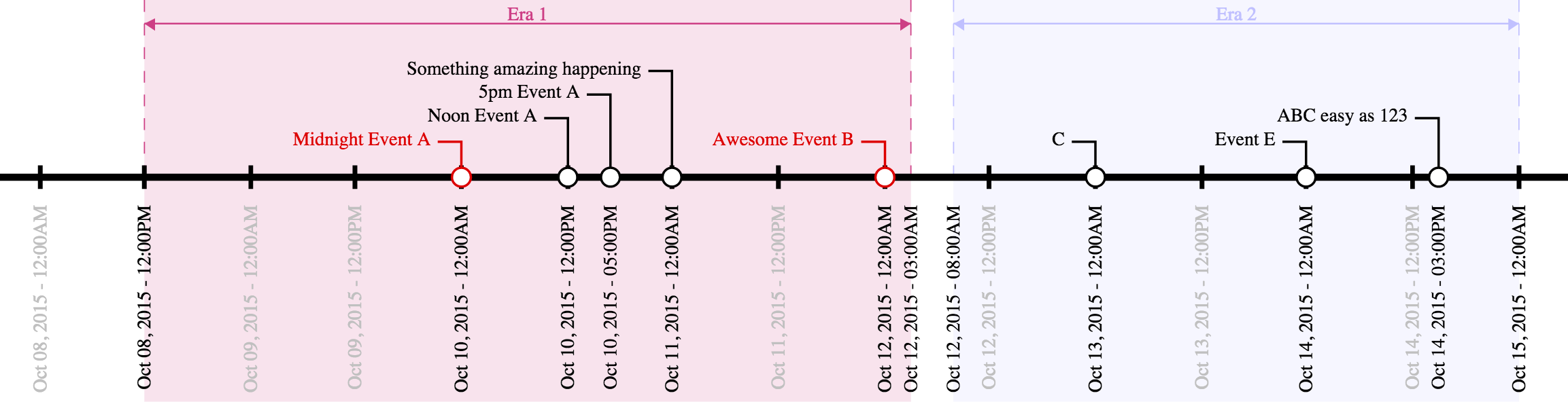
from JSON that looks like this:

{
	"width" : 750,
	"start" : "Oct 8 2015",
	"end" : "Oct 15 2015",	
	"num_ticks" : 14,
	"tick_format" : "%b %d, %Y - %I:%M%p",
	"callouts" : [
		["ABC easy as 123", "Oct 14, 2015 3pm"],		
		["Midnight Event A", "12am Oct 10, 2015", "#DD0000"],
		["Noon Event A", "12pm Oct 10, 2015"],		
		["5pm Event A", "5pm Oct 10, 2015"],				
		["Something amazing happening", "Oct 11, 2015"],
		["Awesome Event B", "Oct 12, 2015", "#DD0000"],
		["C", "Oct 13, 2015"],
		["Event E", "Oct 14, 2015"]
	],
	"eras" : [
		["Era 1", "12pm Oct 8, 2015", "3am Oct 12, 2015", "#CD3F85"],
		["Era 2", "8am Oct 12, 2015", "12am Oct 15, 2015", "#C0C0FF"]
	]
}

Data Format

The input file is a JSON document that describes the start and end points of the timeline, tickmarks along the main axis, as well as callouts to specifc dates/times, and eras which visually mark areas along the axis. Many of the fields are dates, which can be described in several common date formats (e.g., "3/14/15", "Nov 11, 2011", etc.) and may optionally also include a time of day (e.g. "3/14/15 9:26am"). (Date/time parsing is handled by the Python package parsedatetime, which parses many formats.)

Required Fields

The only required fields are width, start, and end. All other fields are optional.

  • width describes the width, in pixels, of the output SVG document. The height will be determined automatically.
  • start is the date/time of the leftmost date/time on the axis.
  • end is the date/time of the rightmost date/time on the axis.

Optional Fields

  • num_ticks contols the number of tickmarks along the axis between the start and end date/times (inclusive). If this field is not present, no tickmarks will be generated except for those at the start and end dates.
  • tick_format describes the string format of the tickmarks along the axis. It follows the Python datetime formatting conventions.

Callouts

Callouts along the axis are described in the callouts list. Each entry in the callouts list is itself a list with either two or three values, all of which are strings. The first two values are required, while the third is optional. The first value is the text description of the callout (e.g., "Pi Day"), and the second value is the date/time of the callout (e.g., "3/14/15 9:26am"). The optional third value can specify a color for the callout, either a color hexcode starting with a # or a SVG color alias.

Example:

["Ultimate Pi Day", "3/14/15 9:26am"]

or, with a custom callout color:

["Ultimate Pi Day", "3/14/15 9:26am", "#CD3F85"]

Eras

Eras are described in the eras list. Like the callout list, each entry in the eras list is itself a list with either three or four values. The first three are required while the fourth is option; all values are strings. The first value is a text description of the era (e.g., "Summer"), while the second and third values are the start and end date/times of the era, respectively (e.g., "6/21/15 12am", and "9/20/15 11:59pm"). The optional fourth value can specify a color for the era, either a color hexcode starting with a # or a SVG color alias.

Example:

["Summer 2015", "6/21/15 12am", "9/20/15 11:59pm"]

or, with a custom era color:

["Summer 2015", "6/21/15 12am", "9/20/15 11:59pm", "Orange"]

Prerequisites

You must have a python 2.7 installation and install the Python packages parsedatetime and svgwrite.

Usage

./make_timeline.py in.json > out.svg

Owner
Jason Reisman
Jason Reisman
A research of IT labor market based especially on hh.ru. Salaries, rate of technologies and etc.

hh_ru_research Проект реализован в учебных целях анализа рынка труда, в особенности по hh.ru Input data В качестве входных данных используются сериали

3 Sep 07, 2022
A python visualization of the A* path finding algorithm

A python visualization of the A* path finding algorithm. It allows you to pick your start, end location and make obstacles and then view the process of finding the shortest path. You can also choose

Kimeon 4 Aug 02, 2022
Squidpy is a tool for the analysis and visualization of spatial molecular data.

Squidpy is a tool for the analysis and visualization of spatial molecular data. It builds on top of scanpy and anndata, from which it inherits modularity and scalability. It provides analysis tools t

Theis Lab 251 Dec 19, 2022
📊📈 Serves up Pandas dataframes via the Django REST Framework for use in client-side (i.e. d3.js) visualizations and offline analysis (e.g. Excel)

📊📈 Serves up Pandas dataframes via the Django REST Framework for use in client-side (i.e. d3.js) visualizations and offline analysis (e.g. Excel)

wq framework 1.2k Jan 01, 2023
🧇 Make Waffle Charts in Python.

PyWaffle PyWaffle is an open source, MIT-licensed Python package for plotting waffle charts. It provides a Figure constructor class Waffle, which coul

Guangyang Li 528 Jan 02, 2023
Backend app for visualizing CANedge log files in Grafana (directly from local disk or S3)

CANedge Grafana Backend - Visualize CAN/LIN Data in Dashboards This project enables easy dashboard visualization of log files from the CANedge CAN/LIN

13 Dec 15, 2022
A Jupyter - Leaflet.js bridge

ipyleaflet A Jupyter / Leaflet bridge enabling interactive maps in the Jupyter notebook. Usage Selecting a basemap for a leaflet map: Loading a geojso

Jupyter Widgets 1.3k Dec 27, 2022
a plottling library for python, based on D3

Hello August 2013 Hello! Maybe you're looking for a nice Python interface to build interactive, javascript based plots that look as nice as all those

Mike Dewar 1.4k Dec 28, 2022
Data aggregated from the reports found at the MCPS COVID Dashboard into a set of visualizations.

Montgomery County Public Schools COVID-19 Visualizer Contents About this project Data Support this project About this project Data All data we use can

James 3 Jan 19, 2022
Massively parallel self-organizing maps: accelerate training on multicore CPUs, GPUs, and clusters

Somoclu Somoclu is a massively parallel implementation of self-organizing maps. It exploits multicore CPUs, it is able to rely on MPI for distributing

Peter Wittek 239 Nov 10, 2022
Geocoding library for Python.

geopy geopy is a Python client for several popular geocoding web services. geopy makes it easy for Python developers to locate the coordinates of addr

geopy 3.8k Jan 02, 2023
Painlessly create beautiful matplotlib plots.

Announcement Thank you to everyone who has used prettyplotlib and made it what it is today! Unfortunately, I no longer have the bandwidth to maintain

Olga Botvinnik 1.6k Jan 06, 2023
NW 2022 Hackathon Project by Angelique Clara Hanzel, Aryan Sonik, Damien Fung, Ramit Brata Biswas

Spiral-Data-Visualizer NW 2022 Hackathon Project by Angelique Clara Hanzell, Aryan Sonik, Damien Fung, Ramit Brata Biswas Description This project vis

Damien Fung 2 Jan 16, 2022
A flexible tool for creating, organizing, and sharing visualizations of live, rich data. Supports Torch and Numpy.

Visdom A flexible tool for creating, organizing, and sharing visualizations of live, rich data. Supports Python. Overview Concepts Setup Usage API To

FOSSASIA 9.4k Jan 07, 2023
This package creates clean and beautiful matplotlib plots that work on light and dark backgrounds

This package creates clean and beautiful matplotlib plots that work on light and dark backgrounds. Inspired by the work of Edward Tufte.

Nico Schlömer 205 Jan 07, 2023
Open-questions - Open questions for Bellingcat technical contributors

Open questions for Bellingcat technical contributors These are difficult, long-term projects that would contribute to open source investigations at Be

Bellingcat 234 Dec 31, 2022
A tool for automatically generating 3D printable STLs from freely available lidar scan data.

mini-map-maker A tool for automatically generating 3D printable STLs from freely available lidar scan data. Screenshots Tutorial To use this script, g

Mike Abbott 51 Nov 06, 2022
A tool for creating Toontown-style nametags in Panda3D

Toontown-Nametag Toontown-Nametag is a tool for creating Toontown Online/Toontown Rewritten-style nametags in Panda3D. It contains a function, createN

BoggoTV 2 Dec 23, 2021
Here are my graphs for hw_02

Let's Have A Look At Some Graphs! Graph 1: State Mentions in Congressperson's Tweets on 10/01/2017 The graph below uses this data set to demonstrate h

7 Sep 02, 2022
3D Vision functions with end-to-end support for deep learning developers, written in Ivy.

Ivy vision focuses predominantly on 3D vision, with functions for camera geometry, image projections, co-ordinate frame transformations, forward warping, inverse warping, optical flow, depth triangul

Ivy 61 Dec 29, 2022