Manipulate EXIF and IFD metadata.

Overview

Tyf

Copyright

pypi

Distribution

pypi pypi pypi Downloads

Support this project

Liberapay receiving

Buy Ѧ and:

Why this package ?

Tyf package provides pythonic way to work with embeded data in TIFF and JPEG images.

Documentation

The Tyf Project [WIP]

Read / write EXIF and IFD data

  • read / edit EXIF data from JPEG images
  • read / edit IFD data from TIFF images
  • read / edit GEOTIFF data from IFD
  • read / edit XMP data from IFD
  • work directly with python numbers, string and datetime
  • interpolate map coordinates using GEOTIFF ModelTransformation

Do more with JPEG and TIFF files

  • extract TIFF or JPEG thumbnails from JPEG files
  • strip EXIF data from JPEG File
  • dump EXIF data from JPEG into file
  • dump location thumbnail using any map provider API

Quick view

>> jpg.__class__ >>> print(Tyf.xmp.tostring(jpg.xmp).decode()) Beautifull Rainbow Beautifull Rainbow THOORENS Bruno THOORENS Bruno 4 75 Rainbow Belgium Rainbow Belgium >>> jpg.save_thumbnail("test/test_thumb") # extension automatically added">
>>> import Tyf
>>> jpg = Tyf.open("test/IMG_20150730_210115.jpg")
>>> jpg.__class__
<class 'Tyf.JpegFile'>
>>> print(Tyf.xmp.tostring(jpg.xmp).decode()) 
<ns0:xmpmeta xmlns:dc="http://purl.org/dc/elements/1.1/" xmlns:ns0="adobe:ns:meta/" xmlns:ns3="http://ns.adobe.com/xap/1.0/" xmlns:ns4="http://ns.microsoft.com/photo/1.0/" xmlns:rdf="http://www.w3.org/1999/02/22-rdf-syntax-ns#"><rdf:RDF><rdf:Description rdf:about="uuid:faf5bdd5-ba3d-11da-ad31-d33d75182f1b"><dc:title><rdf:Alt><rdf:li xml:lang="x-default">Beautifull Rainbow</rdf:li></rdf:Alt>
  </dc:title><dc:description><rdf:Alt><rdf:li xml:lang="x-default">Beautifull Rainbow</rdf:li></rdf:Alt>
  </dc:description><dc:creator><rdf:Seq><rdf:li>THOORENS Bruno</rdf:li></rdf:Seq>
  </dc:creator><dc:rights><rdf:Alt><rdf:li xml:lang="x-default">THOORENS Bruno</rdf:li></rdf:Alt>
  </dc:rights></rdf:Description><rdf:Description rdf:about="uuid:faf5bdd5-ba3d-11da-ad31-d33d75182f1b" /><rdf:Description rdf:about="uuid:faf5bdd5-ba3d-11da-ad31-d33d75182f1b"><ns3:Rating>4</ns3:Rating></rdf:Description><rdf:Description rdf:about="uuid:faf5bdd5-ba3d-11da-ad31-d33d75182f1b"><ns4:Rating>75</ns4:Rating><ns4:LastKeywordXMP><rdf:Bag><rdf:li>Rainbow</rdf:li><rdf:li>Belgium</rdf:li></rdf:Bag>
  </ns4:LastKeywordXMP></rdf:Description><rdf:Description rdf:about="uuid:faf5bdd5-ba3d-11da-ad31-d33d75182f1b"><dc:subject><rdf:Bag><rdf:li>Rainbow</rdf:li><rdf:li>Belgium</rdf:li></rdf:Bag>
  </dc:subject></rdf:Description></rdf:RDF></ns0:xmpmeta>
>>> jpg.save_thumbnail("test/test_thumb") # extension automatically added

EXIF thumbnail

There are 3 attributes to access data within Tyf.JpegFile :

  • ifd0 containing picture IFD, EXIF and eventually GPS data
  • ifd1 containing thubnail data
  • xmp containing XMP data

ifd0 and ifd1 are shortcut to the first and second IFD in ifd attribute which is itself a Tyf.TiffFile.

>> jpg.ifd0[256], jpg.ifd0.get("ImageWidth").comment (2560, 'Number of columns in the image, ie, the number of pixels per row') >>> jpg.ifd0["GPSLongitude"] 5.1872093">
>>> jpg.ifd[0] == jpg.ifd0
True
>>> jpg.ifd[1] == jpg.ifd1
True
>>> jpg.ifd.__class__
<class 'Tyf.TiffFile'>
>>> jpg.ifd0[256]
2560
>>> jpg.ifd0["ImageWidth"]
2560
>>> jpg.ifd0[256], jpg.ifd0.get("ImageWidth").comment
(2560, 'Number of columns in the image, ie, the number of pixels per row')
>>> jpg.ifd0["GPSLongitude"]
5.1872093

Tyf.ifd.Ifd class

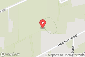
>> jpg.ifd0.get_location() (5.1872093, 51.2095416, -0.0) >>> from Tyf import ifd >>> ifd.dump_mapbox_location(jpg.ifd0, "test/test_location.png")">
>>> jpg.ifd0.__class__
<class 'Tyf.ifd.Ifd'>
>>> for tag in jpg.ifd0.tags(): print(tag)
...
<IFD tag ImageWidth:2560>
<IFD tag ImageLength:1920>
<IFD tag Make:'Google'>
<IFD tag Model:'Nexus S'>
<IFD tag Orientation:1 - Normal>
<IFD tag Software:'KVT49L'>
<IFD tag DateTime:datetime.datetime(2015, 7, 30, 21, 1, 16)>
<IFD tag Artist:'THOORENS Bruno'>
<IFD tag YCbCrPositioning:1 - Centered>
<IFD tag Copyright:'THOORENS Bruno'>
<IFD tag Exif IFD:2286>
<IFD tag GPS IFD:4754>
<IFD tag XPTitle:'Beautifull Rainbow'>
<IFD tag XPComment:'For testing purpose only !'>
<IFD tag XPAuthor:'THOORENS Bruno'>
<IFD tag XPKeywords:'Rainbow;Belgium'>
<IFD tag ExposureTime:0.008333333333333333>
<IFD tag FNumber:2.6>
<IFD tag ExposureProgram:3 - Aperture priority>
<IFD tag ISOSpeedRatings:50>
<IFD tag ExifVersion:b'0220'>
<IFD tag DateTimeOriginal:datetime.datetime(2015, 7, 30, 21, 1, 16)>
<IFD tag DateTimeDigitized:datetime.datetime(2015, 7, 30, 21, 1, 16)>
<IFD tag ShutterSpeedValue:7.0>
<IFD tag ApertureValue:3.0>
<IFD tag BrightnessValue:6.0>
<IFD tag ExposureBiasValue:0.0>
<IFD tag MaxApertureValue:3.0>
<IFD tag MeteringMode:2 - Center Weighted Average>
<IFD tag Flash:0 - Flash did not fire>
<IFD tag FocalLength:3.43>
<IFD tag ColorSpace:1 - RGB>
<IFD tag PixelXDimension:2560>
<IFD tag PixelYDimension:1920>
<IFD tag ExposureMode:0 - Auto exposure>
<IFD tag WhiteBalance:0 - Auto white balance>
<IFD tag SceneCaptureType:0 - Standard>
<IFD tag GPSVersionID:(2, 2, 0, 0)>
<IFD tag GPSLatitudeRef:'N'>
<IFD tag GPSLatitude:51.2095416>
<IFD tag GPSLongitudeRef:'E'>
<IFD tag GPSLongitude:5.1872093>
<IFD tag GPSAltitudeRef:0 - Above sea level>
<IFD tag GPSAltitude:0.0>
<IFD tag GPSTimeStamp:datetime.time(19, 1, 7)>
<IFD tag GPSImgDirectionRef:'M'>
<IFD tag GPSImgDirection:33.0>
<IFD tag GPSProcessingMethod:b'ASCII\x00\x00\x00NETWORK'>
<IFD tag GPSDateStamp:datetime.date(2015, 7, 30)>
>>> jpg.ifd0.get("Orientation").info
'Normal'
>>> jpg.ifd0.get_location()
(5.1872093, 51.2095416, -0.0)
>>> from Tyf import ifd
>>> ifd.dump_mapbox_location(jpg.ifd0, "test/test_location.png")

5.1872093, 51.2095416

>>> jpg.ifd0.set_location(4.362859, 48.958472, 0)
>>> ifd.dump_mapbox_location(jpg.ifd0, "test/test_location2.png")

4.362859, 48.958472

Contribute

Bug report & feedback

Use project issues.

Add / modify / fix code

Guidance words: keep it simple and solid!

  1. open a issue to propose your contribution
  2. once issue is granted
    • fork this repository
    • edit your contribution
    • start a pull request
Comments
  • Unable to open tif file on Linux but works on Windows

    Unable to open tif file on Linux but works on Windows

    Salut,

    Ce problème n'apparait que sur une machine linux, le même fichier se lit correctement sur windows.

    Ci-dessous le message d'erreur:

    File "/usr/local/lib/python3.4/dist-packages/Tyf/__init__.py", line 58, in _read_IFD typ = TYPES[typ][0] KeyError: 0

    Dispo si besoin d'infos complémentaires

    Merci

    bug 
    opened by domlysz 12
  • Restricted Geokey ?

    Restricted Geokey ?

    Salut,

    J'ai une erreur avec un geotiff :

    /Tyf/gkd.py", line 105, in __init__
    ValueError: "GeogGeodeticDatumGeoKey" value must be one of [6016, ... 6001], get 6171 instead
    

    D'après la doc les valeurs entre 6000 et 6199 sont valides, le dictionnaire qu'ils présentent n'est donc pas exhaustif.

    Possible de lever cette restriction ?

    opened by domlysz 7
  • Issue with saving

    Issue with saving

    Hi there,

    I am guessing this is a recurrence of previous issues. This is a simple code: import numpy as np import Tyf import tifffile as tiff

    filename="Test.tif" outputname="output.tif"

    img = tiff.imread(filename) exif_info = Tyf.open(filename)

    tiff.imsave(outputname, img) exif_info.save(outputname)

    And I got following error: Traceback (most recent call last): File "J:/notebook/simple_test_exif.py", line 12, in exif_info.save(outputname) File "C:\Users\sean_\AppData\Local\Programs\Python\Python37\lib\site-packages\Tyf_init_.py", line 352, in save next_ifd = to_buffer(i, fileobj, next_ifd, byteorder) File "C:\Users\sean_\AppData\Local\Programs\Python\Python37\lib\site-packages\Tyf_init_.py", line 252, in to_buffer next_ifd_offset = dump(obj, fileobj, offset, byteorder) File "C:\Users\sean_\AppData\Local\Programs\Python\Python37\lib\site-packages\Tyf_init_.py", line 250, in dump dump(getattr(i, "%s"%tag), f, i.get(tag).value[0], b) File "C:\Users\sean\AppData\Local\Programs\Python\Python37\lib\site-packages\Tyf_init_.py", line 251, in dump return write_IFD(i,f,o,b) File "C:\Users\sean\AppData\Local\Programs\Python\Python37\lib\site-packages\Tyf_init_.py", line 162, in write_IFD pack(byteorder+fmt, fileobj, value) File "C:\Users\sean\AppData\Local\Programs\Python\Python37\lib\site-packages\Tyf_init_.py", line 14, in pack = lambda fmt, fileobj, value: fileobj.write(struct.pack(fmt, *value)) struct.error: ubyte format requires 0 <= number <= 255

    I've also attached the zipped TIF file for your reference. Could you please take a look?

    Thanks, Sean

    test.zip

    opened by seanliu-oss 5
  • wrong data type?

    wrong data type?

    I'm testing a script to read and write a 16bit RGB-colored tiff file and find some error on data type. My test script is very simple like:

    tif = Tyf.open(file_name)
    tif.save(new_file_name)
    

    and result in an error:

    struct.error: ubyte format requires 0 <= number <= 255
    

    After digging into the source file I find that data type of some tags might be wrong. For example in tags.py line 200, the ISOSpeedRatings tag type is set as 1, while it is of type 3 when read from a tiff file (use function _read_IFD in __init__.py). Several data type mismatches has been found, including ExposureProgram, MeteringMode, Flash, ColorSpace, FocalPlaneResolutionUnit, CustomRendered, ExposureMode, WhiteBalance, SceneCaptureType.

    I'm not sure whether it is a problem of a special file format or of the OS platform, or anything else. Does anyone has met similar problems?

    opened by LoveDaisy 4
  • Corrupted files (re)saving TIFF images

    Corrupted files (re)saving TIFF images

    Simple operation of (re)saving TIFF image file

    i1 = Tyf.open( '/Users/xatx/Desktop/TEST.tiff' ) i1.save( '/Users/xatx/Desktop/TESTTyf.tiff' )

    produces a corrupted file.

    opened by aritgithub 3
  • Push current repo and version to pip

    Push current repo and version to pip

    Ran into current pip: https://pypi.org/project/Tyf/ @ 1.3.2

    Ran into bugger:

    WARNING:  Traceback (most recent call last):
      File "<string>", line 29, in __plpython_procedure_find_exif_19256322
      File "/usr/local/lib/python3.5/dist-packages/Tyf/ifd.py", line 75, in decode
        return self._decoder(self.value)
      File "/usr/local/lib/python3.5/dist-packages/Tyf/decoders.py", line 54, in <lambda>
        _0x132 = _0x9003 = _0x9004 = lambda value: datetime.datetime.strptime(_2(value).decode(), "%Y:%m:%d %H:%M:%S")
    AttributeError: 'str' object has no attribute 'decode'
    

    Reviewed current code and this was supposed to be fixed. Current pip is old code? Not sure.

    opened by disarticulate 2
  • Error with InteropIFD : missing / corrupted after save

    Error with InteropIFD : missing / corrupted after save

    I have an issue with the sub IFD InteropIFD : when I load a jpg and save it, it is missing or shown as corrupt in exiftool after (with this example, it's corrupted). I guess it's not the expected behaviour.

    Before :

    Interoperability Index          : R98 - DCF basic file (sRGB)
    Interoperability Version        : 0100
    

    after :

    Warning                         : Bad InteropIFD directory
    

    Steps :

    jpg = Tyf.open('testori.jpg')
    #Print some tags
    for i in jpg.exif.tags():
        print(i)
    # eventually, (re)write 3-4 tags
    jpg.save('testinterop.jpg')
    

    The source file might be corrupted, but it should be original from the smartphone.

    Files : testori testinterop

    Python 3.5.2 64bit Win

    opened by u1735067 2
  • Use enum for the types ?

    Use enum for the types ?

    I may have missed the explanation about this, but I wanted to understand the format used in tags.py and I had to find what is the second field, then try to see where those values are used. I figured out it's Type after following code. Maybe a comment could be added to explain the format ? Also I think the type specification system used, ie. list of integers, is hard to follow and should be written as enum if possible ?

    Just my feedback from trying to understand how it works, but it might makes other/future maintainers life easier.

    opened by u1735067 2
  • location_dump doesnt not work sometimes

    location_dump doesnt not work sometimes

    Hello,

    at first thanks for this library!!!

    But i have little problem with some images. I wrote a script to add EXIF-Tags with GPS to Images which don't have any. This works ok as far i can see

    part of script:

            img = Image.open(os.path.join('pictures', filename))
            exf = img._getexif()
            exf[0]['GPSLatitude'] = lpi[2]
            exf[0]['GPSLongitude'] = lpi[1]
            exf[0]['GPSAltitude'] = 0.00
            exf[1]['GPSLatitude'] = lpi[2]
            exf[1]['GPSLongitude'] = lpi[1]
            exf[1]['GPSAltitude'] = 0.00
            img.save(os.path.join('tagged', 'tagged_' + filename), ifd=exf)
    

    but jpg.exif.dump_location doesnt create images of location. For any photo taken with my Iphone which adds GPS-Tags automatically it works.

    What did i miss??

    Thanks Peter

    opened by spacemishka 2
  • open(jpg) I/O operation on closed file

    open(jpg) I/O operation on closed file

    Hi, Windows 10, python 3.5, blender 2.77, Pillow throw an "I/O operation on closed file" exception on exif = Tyf.open(filepath) when filepath is a jpg.

    Seem to be a magic number issue

    opened by s-leger 1
  • a little help for a newbie

    a little help for a newbie

    Hi, I just stumbled across your Tyf library. I need to write exif data to tiff files. But I can't figure out how to do it. Could you kindly give me a short example on how to write a UserComment to a tif file, so that the rest of the exif info is preserved? Thanks...

    opened by ZacDiggum 1
Releases(1.4.3)
  • 1.4.3(Dec 27, 2020)

    $> python -m pip install Tyf==1.4.3
    

    New features

    • [x] issue #15 fix
    • [x] Tyf.ifd.Ifd class is now an iterable
    • [x] custom map provider url for location dumps
    • [x] minor bugfixes

    Work in progress

    • [ ] Code documentation

    TODO

    • [ ] Test suite
    Source code(tar.gz)
    Source code(zip)
Python Digital Art Generator

Python Digital Art Generator The main goal of this repository is to generate all possible layers permutations given by the user in order to get unique

David Cuentas Mar 3 Mar 12, 2022
Image Processing - Make noise images clean

影像處理-影像降躁化(去躁化) (Image Processing - Make Noise Images Clean) 得力於電腦效能的大幅提升以及GPU的平行運算架構,讓我們能夠更快速且有效地訓練AI,並將AI技術應用於不同領域。本篇將帶給大家的是 「將深度學習應用於影像處理中的影像降躁化 」,

2 Aug 04, 2022
Fix datetime EXIF data in photos downloaded from Google Takeout

fix-google-takeout Warning Use at your own risk. Backup your photos. Overview Google takeout for photos

Mayank Mandava 20 Nov 05, 2022
Typesheet is a tiny Python script for creating transparent PNG spritesheets from TrueType (.ttf) fonts.

typesheet typesheet is a tiny Python script for creating transparent PNG spritesheets from TrueType (.ttf) fonts. I made it because I couldn't find an

Grayson Chao 12 Dec 23, 2022
Hacking github graph with a easy python script

Hacking-Github-Graph Hacking github graph with a easy python script Requirements git latest version installed. A text editor (eg: vs code, sublime tex

SENPAI LEGEND 1 Nov 01, 2021
Console images in 48 colors, 216 colors and full rgb

console_images Console images in 48 colors, 216 colors and full rgb Full RGB 216 colors 48 colors If it does not work maybe you should change color_fu

Урядов Алексей 5 Oct 11, 2022
📷 Python package and CLI utility to create photo mosaics.

📷 Python package and CLI utility to create photo mosaics.

Loic Coyle 7 Oct 29, 2022
This tool allows the user to convert a 16 by 16 image into a list with numbers representing an object/character.

Room Formatter This tool allows the user to convert a 16 by 16 image into a list with numbers representing an object/character. There is cur

Thomas Landstra 1 Nov 13, 2021
SALaD (Semi-Automatic Landslide Detection) is a landslide mapping system

SALaD (Semi-Automatic Landslide Detection) is a landslide mapping system. SALaD utilizes Object-based Image Analysis and Random Forest to map landslides.

NASA 14 Jan 04, 2023
python app to turn a photograph into a cartoon

Draw This. Draw This is a polaroid camera that draws cartoons. You point, and shoot - and out pops a cartoon; the camera's best interpretation of what

Dan Macnish 2k Dec 19, 2022
Demo of using Auto Encoder for Image Denoising

Demo of using Auto Encoder for Image Denoising

2 Aug 04, 2022
A simple programming language for manipulating images.

f-stop A simple programming language for manipulating images. Examples OPEN "image.png" AS image RESIZE image (300, 300) SAVE image "out.jpg" CLOSE im

F-Stop 6 Oct 27, 2022
Simple Python package to convert an image into a quantized image using a customizable palette

Simple Python package to convert an image into a quantized image using a customizable palette. Resulting image can be displayed by ePaper displays such as Waveshare displays.

Luis Obis 3 Apr 13, 2022
A simple programme for converting url into a qr code (.png file)

QrTk A simple lightweight programme for converting url into a qr code (.png file) Pre-Requisites Before installing the programme , you need to run the

Juss Patel 4 Nov 08, 2021
Generate different types of random avatars.

avatar-generator Generate different types of random avatars. Requirements Python3 pytorch=1.6 cv2=3.4 tqdm 1. Github-like avatars python generate_gi

Ming 11 Apr 02, 2022
Forza painter app with python

forza-painter Discord: A-Dawg#0001 (AE) Supports: Forza Horizon 5 Offically (OTHER v1.405.2.0, MS STORE v3.414.967.0, STEAM v1.414.967.0) Unofficially

320 Dec 31, 2022
Image Processing HighPass Filter With Python

Image_Processing_HighPassFilter High Pass Filter take the high frequency and ignore the low frequency High Pass Filter can be use to sharpening an ima

Felix Pratamasan 1 Dec 27, 2021
🎨 Generate and change color-schemes on the fly.

Generate and change color-schemes on the fly. Pywal is a tool that generates a color palette from the dominant colors in an image. It then applies the

dylan 6.9k Jan 03, 2023
Plots the graph of a function with ASCII characters.

ASCII Graph Plotter Plots the graph of a function with ASCII characters. See the change log here. Developed by InformaticFreak (c) 2021 How to use py

InformaticFreak 2 Apr 29, 2022
Dynamic image server for web and print

Quru Image Server - dynamic imaging for web and print QIS is a high performance web server for creating and delivering dynamic images. It is ideal for

Quru 84 Jan 03, 2023