Mmdb-server - An open source fast API server to lookup IP addresses for their geographic location

Overview

mmdb-server

mmdb-server is an open source fast API server to lookup IP addresses for their geographic location. The server can be used with any MaxMind DB File Format or file in the same format.

mmdb-server includes a free and open GeoOpen-Country database for IPv4 and IPv6 addresses. The file GeoOpen-Country is generated on a regular basis from AS announces and their respective whois records.

Installation

Python 3.8+ is required to run the mmdb-server with some additional requirements.

  • pip3 install -r REQUIREMENTS
  • cp ./etc/server.conf.sample ./etc/server.conf
  • cd bin; python3 server.py

Usage

Lookup of an IP address

curl -s http://127.0.0.1:8000/geolookup/188.65.220.25 | jq .

[
  {
    "country": {
      "iso_code": "BE"
    },
    "meta": {
      "description": {
        "en": "Geo Open MMDB database - https://github.com/adulau/mmdb-server"
      },
      "build_db": "2022-01-23 16:13:05",
      "db_source": "GeoOpen-Country",
      "nb_nodes": 1156125
    }
  }
]

$ curl -s http://127.0.0.1:8000/geolookup/2a02:21d0::68:69:25 | jq .

[
  {
    "country": {
      "iso_code": "BE"
    },
    "meta": {
      "description": {
        "en": "Geo Open MMDB database - https://github.com/adulau/mmdb-server"
      },
      "build_db": "2022-01-23 16:13:05",
      "db_source": "GeoOpen-Country",
      "nb_nodes": 1156125
    }
  }
]

Output format

The output format is an array of JSON object (to support the ability to serve multiple geo location database). Each JSON object of the JSON array includes a meta and a country fields. The country give the geographic location of the IP address queried. The meta field includes the origin of the MMDB database which the the metadata.

License

    Copyright (C) 2022 Alexandre Dulaunoy 

    This program is free software: you can redistribute it and/or modify
    it under the terms of the GNU Affero General Public License as published by
    the Free Software Foundation, either version 3 of the License, or
    (at your option) any later version.

    This program is distributed in the hope that it will be useful,
    but WITHOUT ANY WARRANTY; without even the implied warranty of
    MERCHANTABILITY or FITNESS FOR A PARTICULAR PURPOSE.  See the
    GNU Affero General Public License for more details.

    You should have received a copy of the GNU Affero General Public License
    along with this program.  If not, see 
   .
You might also like...
LicenseLocation - License Location With Python

LicenseLocation Hi,everyone! ❤ 🧡 💛 💚 💙 💜 This is my first project! ✔ Actual

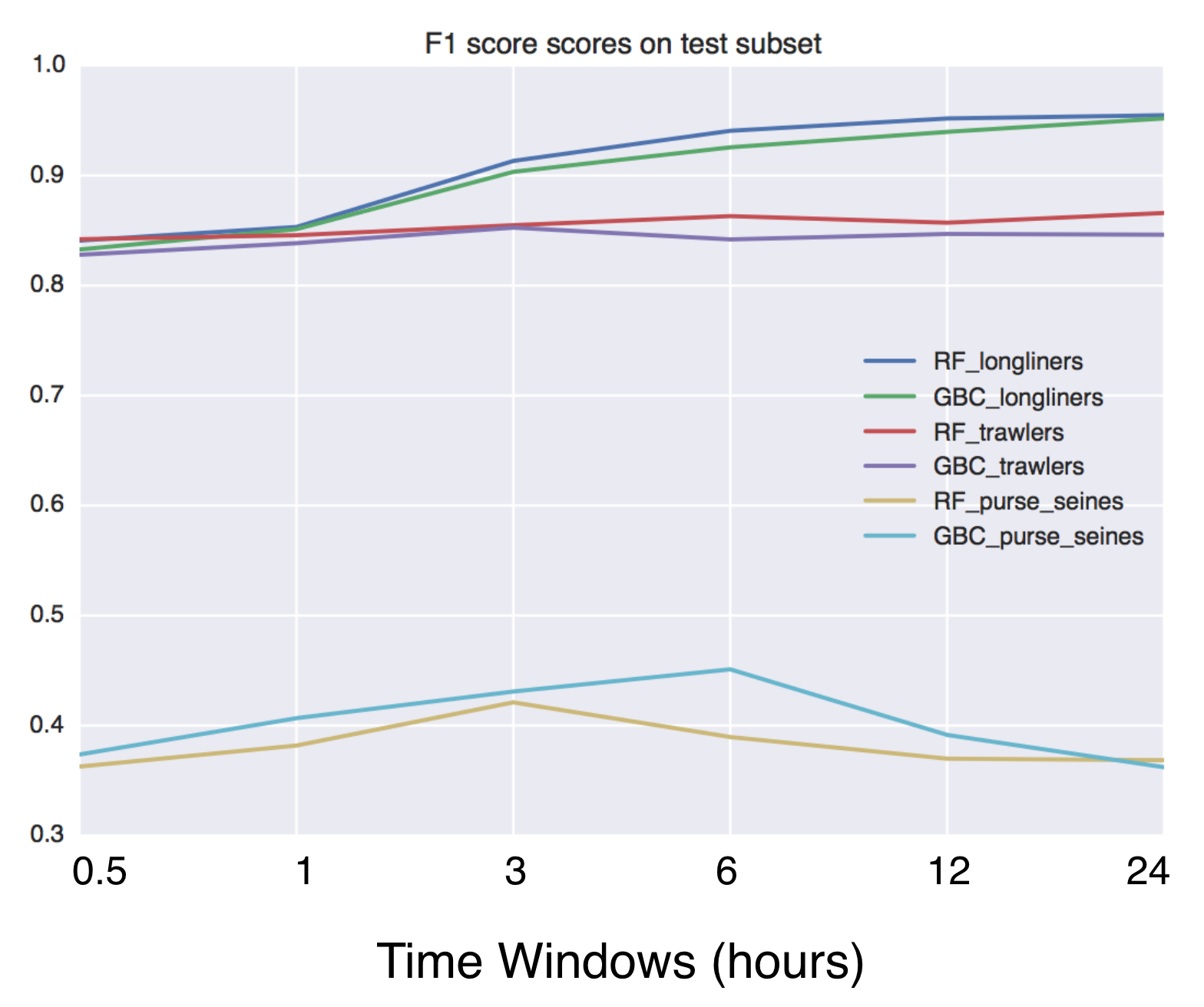
Using Global fishing watch's data to build a machine learning model that can identify illegal fishing and poaching activities through satellite and geo-location data.

Using Global fishing watch's data to build a machine learning model that can identify illegal fishing and poaching activities through satellite and geo-location data.

Script that allows to download data with satellite's orbit height and create CSV with their change in time.

Satellite orbit height ◾ Requirements Python = 3.8 Packages listen in reuirements.txt (run pip install -r requirements.txt) Account on Space Track ◾

Helping data scientists better understand their datasets and models in text classification. With love from ServiceNow.

Azimuth, an open-source dataset and error analysis tool for text classification, with love from ServiceNow. Overview Azimuth is an open source applica

A package built to support working with spatial data using open source python

EarthPy EarthPy makes it easier to plot and manipulate spatial data in Python. Why EarthPy? Python is a generic programming language designed to suppo

GeoNode is an open source platform that facilitates the creation, sharing, and collaborative use of geospatial data.

Table of Contents What is GeoNode? Try out GeoNode Install Learn GeoNode Development Contributing Roadmap Showcase Most useful links Licensing What is

GebPy is a Python-based, open source tool for the generation of geological data of minerals, rocks and complete lithological sequences.

GebPy is a Python-based, open source tool for the generation of geological data of minerals, rocks and complete lithological sequences. The data can be generated randomly or with respect to user-defined constraints, for example a specific element concentration within minerals and rocks or the order of units within a complete lithological profile.

Tile Map Service and OGC Tiles API for QGIS Server

Tiles API Add tiles API to QGIS Server Tiles Map Service API OGC Tiles API Tile Map Service API - TMS The TMS API provides these URLs: /tms/? to get i

Zora is a python program that searches for GeoLocation info for given CIDR networks , with options to search with API or without API

Zora Zora is a python program that searches for GeoLocation info for given CIDR networks , with options to search with API or without API Installing a

Releases(v1.1)
  • v1.1(Oct 15, 2022)

  • v1.0(Jul 9, 2022)

    mmdb-server v1.0 released - an open source fast API server to lookup IP addresses for their geographic location. The server reached version 1.0 as many production servers are running flawlessly with this code. mmdb-server includes the geo-open database from CIRCL.

    Source code(tar.gz)
    Source code(zip)
  • v0.5(Feb 6, 2022)

    mmdb-server (the open and free geo IP server) version 0.5 released (2022-02-06) 🗺️

    mmdb-server (the open and free geo IP server) version 0.5 released which includes the support for to load multiple MMDB files.

    A new GeoOpen database included to support AS number and AS description lookup.

    New

    • [multiple MMDB file support] MMDB server can now load a list of MMDB files + new GeoOpen file including ASN details added as example. [Alexandre Dulaunoy]

      GeoOpen files for country only -> https://cra.circl.lu/opendata/geo-open/mmdb-country/ GeoOpen files with country and ASN/ASN description -> https://cra.circl.lu/opendata/geo-open/mmdb-country-asn/

    • [db] Country-ASN db added. [Alexandre Dulaunoy]

    • [db] GeoOpen database updated. [Alexandre Dulaunoy]

    Changes

    • [doc] update the documentation and examples with the multiple sources. [Alexandre Dulaunoy]

    • [log] remove old debug. [Alexandre Dulaunoy]

    • [db] renamed. [Alexandre Dulaunoy]

    • [GeoOpen-country] updated. [Alexandre Dulaunoy]

    Other

    • Update README.md. [Alexandre Dulaunoy]
    Source code(tar.gz)
    Source code(zip)
  • v0.2(Jan 24, 2022)

    What's new in v0.2 (2022-01-24)

    New

    • [server] Add additional information about the country including average location, complete name and numeric code. [Alexandre Dulaunoy]

    • [mygeolookup] Query on root of the server will give the geo location of the remote IP address doing the query. [Alexandre Dulaunoy]

    Changes

    • [doc] update JSON output and CIRCL public service. [Alexandre Dulaunoy]

    • [server] display port. [Alexandre Dulaunoy]

    • [server] make port configurable. [Alexandre Dulaunoy]

    Source code(tar.gz)
    Source code(zip)
  • v0.1(Jan 23, 2022)

    mmdb-server is an open source fast API server to lookup IP addresses for their geographic location. The server can be used with any MaxMind DB File Format or file in the same format.

    mmdb-server includes a free and open GeoOpen-Country database for IPv4 and IPv6 addresses. The file GeoOpen-Country is generated on a regular basis from AS announces and their respective whois records.

    Installation

    Python 3.8+ is required to run the mmdb-server with some additional requirements.

    • pip3 install -r REQUIREMENTS
    • cp ./etc/server.conf.sample ./etc/server.conf
    • cd bin; python3 server.py

    Usage

    Lookup of an IP address

    curl -s http://127.0.0.1:8000/geolookup/188.65.220.25 | jq .

    [
      {
        "country": {
          "iso_code": "BE"
        },
        "meta": {
          "description": {
            "en": "Geo Open MMDB database - https://github.com/adulau/mmdb-server"
          },
          "build_db": "2022-01-23 16:13:05",
          "db_source": "GeoOpen-Country",
          "nb_nodes": 1156125
        }
      }
    ]
    

    $ curl -s http://127.0.0.1:8000/geolookup/2a02:21d0::68:69:25 | jq .

    [
      {
        "country": {
          "iso_code": "BE"
        },
        "meta": {
          "description": {
            "en": "Geo Open MMDB database - https://github.com/adulau/mmdb-server"
          },
          "build_db": "2022-01-23 16:13:05",
          "db_source": "GeoOpen-Country",
          "nb_nodes": 1156125
        }
      }
    ]
    

    Output format

    The output format is an array of JSON object (to support the ability to serve multiple geo location database). Each JSON object of the JSON array includes a meta and a country fields. The country give the geo graphic location of the IP address queried. The meta field includes the origin of the MMDB database which the the metadata.

    Source code(tar.gz)
    Source code(zip)
Owner
Alexandre Dulaunoy
Enjoy when human are using machines in unexpected ways. I break stuff and I do stuff.
Alexandre Dulaunoy
Extract GoPro highlights and GPMF data.

Python script that parses the gpmd stream for GOPRO moov track (MP4) and extract the GPS info into a GPX (and kml) file.

Chris Auron 2 May 13, 2022
Histogram matching plugin for rasterio

rio-hist Histogram matching plugin for rasterio. Provides a CLI and python module for adjusting colors based on histogram matching in a variety of col

Mapbox 75 Sep 23, 2022
A proof-of-concept jupyter extension which converts english queries into relevant python code

Text2Code for Jupyter notebook A proof-of-concept jupyter extension which converts english queries into relevant python code. Blog post with more deta

DeepKlarity 2.1k Dec 29, 2022
Python module and script to interact with the Tractive GPS tracker.

pyTractive GPS Python module and script to interact with the Tractive GPS tracker. Requirements Python 3 geopy folium pandas pillow usage: main.py [-h

Dr. Usman Kayani 3 Nov 16, 2022
Record railway train route profile with GNSS tools

Train route profile recording with GNSS technology based on ARDUINO platform Project target Develop GNSS recording tools based on the ARDUINO platform

tomcom 1 Jan 01, 2022
iNaturalist observations along hiking trails

This tool reads the route of a hike and generates a table of iNaturalist observations along the trails. It also shows the observations and the route of the hike on a map. Moreover, it saves waypoints

7 Nov 11, 2022
A part of HyRiver software stack for handling geospatial data manipulations

Package Description Status PyNHD Navigate and subset NHDPlus (MR and HR) using web services Py3DEP Access topographic data through National Map's 3DEP

Taher Chegini 5 Dec 14, 2022
Manage your XYZ Hub or HERE Data Hub spaces from Python.

XYZ Spaces for Python Manage your XYZ Hub or HERE Data Hub spaces and Interactive Map Layer from Python. FEATURED IN: Online Python Machine Learning C

HERE Technologies 30 Oct 18, 2022
A package to fetch sentinel 2 Satellite data from Google.

Sentinel 2 Data Fetcher Installation Create a Virtual Environment and activate it. python3 -m venv venv . venv/bin/activate Install the Package via pi

1 Nov 18, 2021
Google maps for Jupyter notebooks

gmaps gmaps is a plugin for including interactive Google maps in the IPython Notebook. Let's plot a heatmap of taxi pickups in San Francisco: import g

Pascal Bugnion 747 Dec 19, 2022
Raster processing benchmarks for Python and R packages

Raster processing benchmarks This repository contains a collection of raster processing benchmarks for Python and R packages. The tests cover the most

Krzysztof Dyba 13 Oct 24, 2022
Replace MSFS2020's bing map to google map

English verison here 中文 免责声明 本教程提到的方法仅用于研究和学习用途。我不对使用、拓展该教程及方法所造成的任何法律责任和损失负责。 背景 微软模拟飞行2020的地景使用了Bing的卫星地图,然而卫星地图比较老旧,很多地区都是几年前的图设置直接是没有的。这种现象在全球不同地区

hesicong 272 Dec 24, 2022
A service to auto provision devices in Aruba Central based on the Geo-IP location

Location Based Provisioning Service for Aruba Central A service to auto provision devices in Aruba Central based on the Geo-IP location Geo-IP auto pr

Will Smith 3 Mar 22, 2022
GeoIP Legacy Python API

MaxMind GeoIP Legacy Python Extension API Requirements Python 2.5+ or 3.3+ GeoIP Legacy C Library 1.4.7 or greater Installation With pip: $ pip instal

MaxMind 230 Nov 10, 2022
Code and coordinates for Matt's 2021 xmas tree

xmastree2021 Code and coordinates for Matt's 2021 xmas tree This repository contains the code and coordinates used for Matt's 2021 Christmas tree, as

Stand-up Maths 117 Jan 01, 2023
A Jupyter - Leaflet.js bridge

ipyleaflet A Jupyter / Leaflet bridge enabling interactive maps in the Jupyter notebook. Usage Selecting a basemap for a leaflet map: Loading a geojso

Jupyter Widgets 1.3k Dec 27, 2022
Geospatial Image Processing for Python

GIPPY Gippy is a Python library for image processing of geospatial raster data. The core of the library is implemented as a C++ library, libgip, with

GIPIT 83 Aug 19, 2022
Python interface to PROJ (cartographic projections and coordinate transformations library)

pyproj Python interface to PROJ (cartographic projections and coordinate transformations library). Documentation Stable: http://pyproj4.github.io/pypr

832 Dec 31, 2022
Geographic add-ons for Django REST Framework. Maintained by the OpenWISP Project.

Geographic add-ons for Django REST Framework. Maintained by the OpenWISP Project.

OpenWISP 982 Jan 06, 2023
Program that shows all the details of the given IP address. Build with Python and ipinfo.io API

ip-details This is a program that shows all the details of the given IP address. Build with Python and ipinfo.io API Usage To use this program, run th

4 Mar 01, 2022